.........................................................................................................................................
Guam is made up of two distinct geographic regions. The south of Guam is volcanic in origin, mountainous and consisting largely of clay soils. Northern Guam is an uplifted limestone plateau created by eons of coral reef growth and plate tectonics. If you look to the north from the “Lookout Point, the uplifted flat limestone plateau is unmistakable. Guam, the largest island of the Marianas archipelago, is part of an active volcanic chain. The island experiences more than 300 earthquakes a year as the Pacific plate shifts under the Asian plate pushing Guam upward. Puntan Dos Amantes and Guam’s northern plateau lifts about an inch every 100 years.
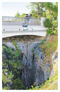
The elevated limestone plateau of the north is also Guam’s most important watershed. Guam’s yearly average rainfall of 100 inches seeps down through the porous limestone and forms fresh water lenses on top of seawater that flows into large underground caverns at various parts in the north. Guam pumps the fresh water up to supply the homes and businesses of Guam with clean drinking water. As the water percolates through the limestone, large caverns are formed. The one at Puntan Dos Amantes is one of Guam’s most famous. It forms a shear drop of more than 20 stories. A small bridge traverses the cavern along the walkway to the “Lookout Point.” If you listen closely, you can almost hear the water droplets as they flow down to bottom through ages of coral reef growth. It’s as if you can hear the legend of Guam.


